Fexeiro:Satellite picture of the Amazon River.jpg

Fexeiro oureginal (1 000 × 581 píxeles, tamanho: 213 KB, tipo MIME: image/jpeg)
Çcriçon de l fexeiro
| Çcriçon |
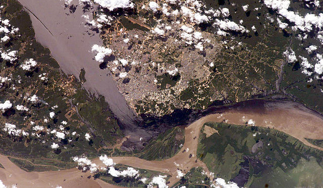
English: Satellite picture of the Amazon River, near the city of Manaus, capital of the state of Amazonas, northen Brazil.
Português: Imagem de satélite do Rio Amazonas, próximo a cidade de Manaus, capital do estado do Amazonas, norte do Brasil.
Original caption — The largest river on the planet, the Amazon, forms from the confluence of the Solimões (the upper Amazon River) and the Negro at the Brazilian city of Manaus in central Amazonas. At the river conjunction, the muddy, tan-colored waters of the Solimões meet the "black" water of the Negro River. The unique mixing zone where the waters meet extends downstream through the rainforest for hundreds of miles, and attracts tourists from all over the world, which has contributed to substantial growth in the city of Manaus. It is the vast quantity of sediment eroded from the Andes Mountains that gives the Solimões its tan color. By comparison, water in the Negro derives from the low jungles where reduced physical erosion of rock precludes mud entering the river. In place of sediment, organic matter from the forest floor stains the river the color of black tea. The Solimões provides nutrient-rich mud to lakes on the floodplain (lower right). The ecology of muddy lakes differs correspondingly from that of nutrient-poor, blackwater rivers and lakes. Solimões water can be seen leaking into the Negro west of the main meeting zone (lower left). The Solimões is much shallower than the Negro because it has filled its valley and bed with great quantities of sediment since the valleys were excavated. Widths of the rivers differ for this reason. |
| Data | 13 de júlio de 2006 |
| Fuonte | NASA (Image galleries) |
| Outor | National Aeronautics and Space Administration (NASA) |
Lhicença
| Este ficheiro está no domínio público nos Estados Unidos porque foi criado exclusivamente pela NASA. As orientações sobre o direito de autor da NASA são que «as obras da NASA não têm os direitos de autor protegidos salvo indicação em contrário». Veja Template:PD-USGov, as orientações sobre o direito de autor da NASA ou as normas de uso de imagens do Laboratório de Propulsão a Jato (Jet Propulsion Lab, JPL). | ||
 |
Avisos:
|
Stórico de l fexeiro
Clique an ua data/hora para ber l fexeiro tal cumo el staba naquel sfergante.
| Data i hora | Amostra | Tamanho | Outelizador | Comentairo | |
|---|---|---|---|---|---|
| atual | 02h50min de 14 de júlio de 2006 | | 1 000 × 581 (213 KB) | Felipe Menegaz | {{Information| |Description= The largest river on the planet, the Amazon, forms from the confluence of the Solimões (the upper Amazon River) and the Negro at the Brazilian city of Manaus in central Amazonas. At the river conjunction, the muddy, tan-color |
Lhigaçones de l fexeiro
Esta páigina lhiga este fexeiro:
Outelizaçon global dun fexeiro
Las seguintes wikis outelizan este fexeiro: