Fexeiro:Habsburg Map 1547.jpg
Fexeiro oureginal (1 654 × 1 029 píxeles, tamanho: 534 KB, tipo MIME: image/jpeg)
Çcriçon de l fexeiro
| Çcriçon |
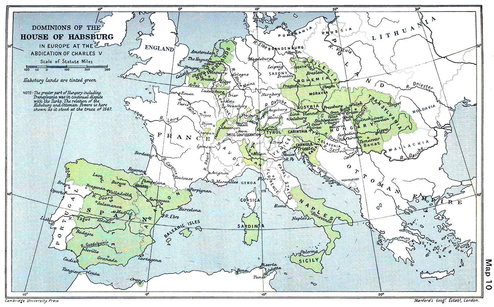
English: A map of the dominion of the Habsburgs following the Battle of Mühlberg (1547) |
| Data | |
| Fuonte |
The Cambridge Modern History Atlas, edited by Sir Adolphus William Ward, G.W. Prothero, Sir Stanley Mordaunt Leathes, and E.A. Benians. Cambridge University Press: London, 1912. Editors were Sir Adolphus William Ward (†1924), G.W. Prothero (†1922), and Sir Stanley Mordaunt Leathes (†1938). Individual authors of works making up the atlas are not identified, nor are the likely to be, after reasonable research. |
| Outor | edited by Sir Adolphus William Ward, G.W. Prothero, Sir Stanley Mordaunt Leathes |
| Outras versões |
|

Lhicença
Esta obra está no domínio público nos Estados Unidos porque foi publicada (ou registada no U.S. Copyright Office) antes de 1 de janeiro de 1929.
Para que possam ser alojadas na wiki Commons, as obras que estão no domínio público não podem ter os direitos de autor protegidos, nem nos Estados Unidos nem no país de origem da obra. Se esta obra não tem origem nos EUA, o ficheiro tem de ter uma marcação de direitos de autor adicional que indique o estado dos direitos de autor no país de origem.
|
This UK artistic or literary work, of which the author is unknown and cannot be ascertained by reasonable enquiry, is in the public domain because it is one of the following:
|
 |
Stórico de l fexeiro
Clique an ua data/hora para ber l fexeiro tal cumo el staba naquel sfergante.
| Data i hora | Amostra | Tamanho | Outelizador | Comentairo | |
|---|---|---|---|---|---|
| atual | 09h20min de 29 de márcio de 2018 | | 1 654 × 1 029 (534 KB) | Trecătorul răcit | Little add: borders of the time |
| 11h01min de 3 de setembre de 2015 |  | 1 654 × 1 029 (518 KB) | Kurzon | Reverted to version as of 17:22, 9 August 2010 | |
| 11h01min de 3 de setembre de 2015 |  | 1 654 × 1 029 (518 KB) | Kurzon | Reverted to version as of 17:22, 9 August 2010 | |
| 21h33min de 29 de júnio de 2013 |  | 1 654 × 1 029 (546 KB) | CSvBibra | add more contrast per request by another user | |
| 17h22min de 9 de agosto de 2010 |  | 1 654 × 1 029 (518 KB) | CSvBibra | Previously put cleaned up version in new file with "b" after name. Now updating original file with "b" version. Both files uses throughout Wikipedias | |
| 09h07min de 28 de agosto de 2008 |  | 1 654 × 1 029 (649 KB) | F l a n k e r | Wrap, shadows and minor improvements | |
| 14h42min de 28 de júnio de 2005 |  | 1 654 × 1 029 (421 KB) | Rythin~commonswiki | A map of the dominion of the Habsburgs following the Battle of Mühlberg (1547). Taken from ''The Cambridge Modern History Atlas,'' edited by Sir Adolphus William Ward, G.W. Prothero, Sir Stanley Mordaunt Leathes, and E.A. Benians. Cambridge University Pr |
Lhigaçones de l fexeiro
Esta páigina lhiga este fexeiro:
Outelizaçon global dun fexeiro
Las seguintes wikis outelizan este fexeiro:
- Outelizaçon na af.wikipedia.org
- Outelizaçon na an.wikipedia.org
- Outelizaçon na ar.wikipedia.org
- Outelizaçon na arz.wikipedia.org
- Outelizaçon na ast.wikipedia.org
- Outelizaçon na azb.wikipedia.org
- Outelizaçon na ba.wikipedia.org
- Outelizaçon na be.wikipedia.org
- Outelizaçon na bg.wikipedia.org
- Outelizaçon na br.wikipedia.org
- Outelizaçon na bs.wikipedia.org
- Outelizaçon na ca.wikipedia.org
- Outelizaçon na cs.wikipedia.org
- Outelizaçon na da.wikipedia.org
- Outelizaçon na de.wikipedia.org
- Outelizaçon na el.wikipedia.org
- Outelizaçon na en.wikipedia.org
Ber la outelizaçon global deste fexeiro.